Doing (the) Charleston

Here are the pictures from the 10th.

The top two are shots from the boat as we approached.  The black thing in the middle of the fort is not original to the fort, but was added during the Spanish-American War to better defend Charleston.  It was named “Battery Huger” (which apparently in South Carolina, Huger is pronounced “yoo-gee”), but never saw action.

The picture in the middle is a plaque honoring the Union soldiers who defended the fort until the surrender, all of whom survived the bombardment.  the bottom two show Fort Sumter before the Civil War, and then after 4 years of bombardment by Union rifled cannon.  The fort was barely damaged by the Confederate damage, but Union shells broke the walls, which started at 50 ft, were now down to, I think, 20 ft or less.

Next, the U.S.S. Yorktown, which is not the original Yorktown, which was sunk at the Battle of Midway.  This one, originally called the Bon Homme Richard, was renamed in her honor.  The bottom right shows the combat record of one of the flight groups stationed on the Yorktown.  It says May 6th, 1945, so possibly this is one day?  The flags are enemy aircraft shot down, the ducks are enemy planes destroyed on the ground, the others show ships damaged or sunk.

The picture on the upper right is a model of the U.S.S. Franklin after being hit by a bomb (this happened in early 1945)  which pierced through several decks before exploding.  I think some 800 sailors were killed and a few hundred injured.  The ship, listing at (if I remember) 13 degrees, without power, and just a few miles from Japan, survived, and while being towed, managed to restart her engines and return to Pearl Harbor, and then New York under her own power.  However, despite being repaired she would never again see service.

Whoops!

So I am getting ready to write about my trip to Charleston, and I realized I left my camera in my car, and I’m too tired to go get it.  So you’ll have to wait till tomorrow to see the pictures.  But I can at least tell you what I did.  Pictures tomorrow, I promise.

I started by going down to the harbor, and getting a ticket to Fort Sumter.  For those who don’t know, it’s a fort on an artificial island in the middle of Charleston Harbor, so you have to get on a boat to go see it.  While I was waiting, I noticed an aircraft carrier sitting in the harbor, which I thought was pretty cool.  I then heard on the way out to the fort that this is the U.S.S. Yorktown, and served in WWII and Vietnam.  It’s now part of a museum there, so of course I had to go see it after I got done at Fort Sumter.  I was then out of time (and energy: it’s hot and humid, in case you didn’t know that), and had to move on, leaving plenty to see next time I come to Charleston.

There’s not much more to say, at least not anything that will make sense without pictures, so you’ll have to be content with that.  Happy Road-Tripping!

Rollin’ on the River

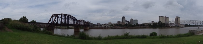
Ok, not really, but I did spend about an hour on a riverboat.  So, back to the beginning.  I started by driving into Savannah.  I first went to book the sightseeing tour of the Savannah River.  Incidentally, here are some pictures of the riverfront area.

If you look close on the right side of the pan shot, you can see the riverboat I was going on, the Georgia Queen.  The picture of the road is to show the cobblestones, which date to colonial times, and are ballast rocks that were left by ships.  If you don’t know what ballast is, I suggest looking it up, it would be a little to complicated to explain here.  The statue is in honor of the men, women, and children who were brought here against their will and enslaved.  There is a poem on the base of the statue that I tried to get a picture of, but it didn’t come out very well.

After I got the ticket, I had some time to kill, so I decided to go tourist and hit the shops that are there.  I lasted about 20 minutes (no bookstore that I could see), and decided to check out a Maritime History museum that I noticed was in the area.  It was very interesting, and had a lot of models and paintings, and some other things.  A lot of it was focused on the Savannah shipping industry, but there was some other things there as well.

Clockwise from the top left: The ship that brought over a hundred settlers to colonize what is now Savannah (I can’t imagine sharing that small a space with that many other people for that long); A poster from the Savannah shipping company after one of their ships was sunk in March 1917 by a German U-boat, which along with 2 other sinkings that month helped propel the U.S. into war; a model of the Titanic sinking; and I assume this statue was on the prow of a ship, but I don’t know any details, there were no info cards connected to it.

I then walked down to where a statue of a girl waving to ships is on the riverfront.

DSC00769

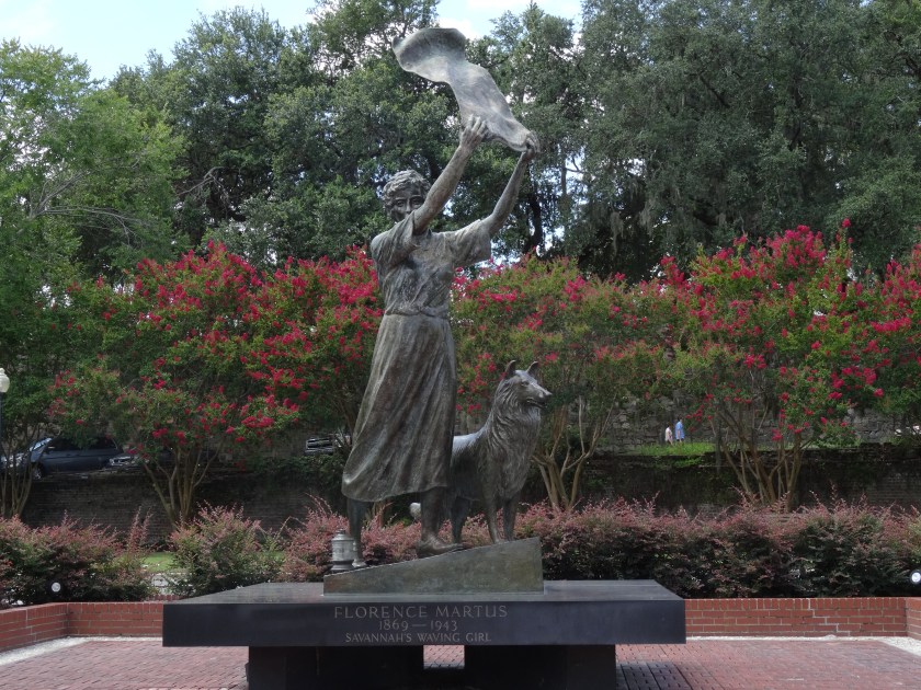
As you can see, her name was Florence, and according to multiple sources, she did this for every ship going in and out of the harbor from her late teens, till she died.  Sailors around the world knew of her, and apparently, sailors today look for the statue, because they heard about her from there fathers and grandfathers (or even great-grandfathers).  Some dispute as to why she did it, but I’ll leave you some mystery to come out here for.

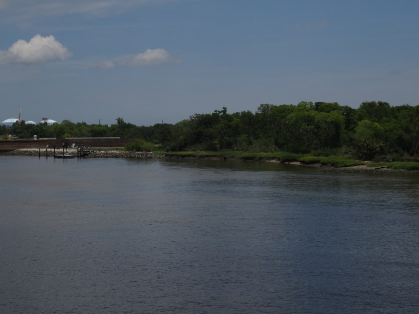
The riverboat was fun, and mostly just facts about the port of Savannah.  Savannah is the 4th busiest port in the U.S., and to accommodate the big ships out there, the river, which for years has been dredged to a depth of 42 feet, is now beginning the process of being dredged to 47 feet.  Long story short, because it’s late, I also visited Forts Jackson and Pulaski, which both were originally built to protect Savannah from the British, but played large roles in the Civil War.  If anyone is interested in more, let me know, but I’ll spare you the history lecture for tonight and just share a few more pictures.

First is a picture of a dredging ship, and a couple pics of an incoming tanker that passed near the steamboat.

DSC00773DSC00774DSC00784DSC00785

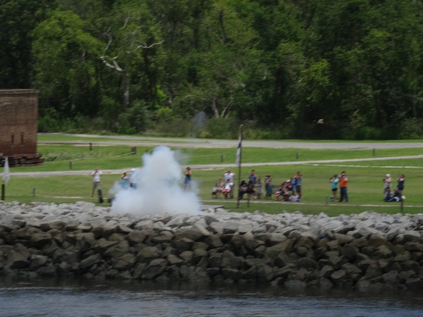
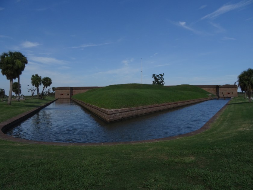
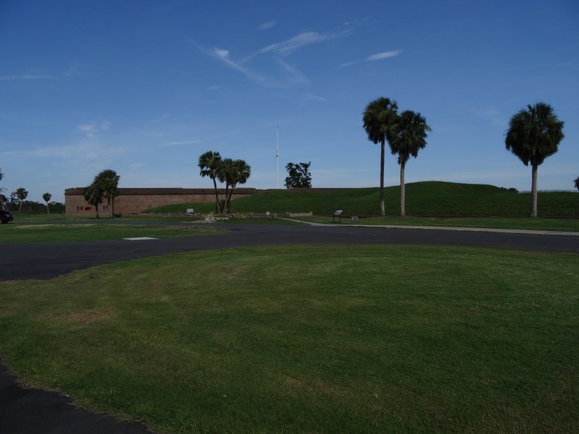
First, Fort Jackson (sorry it’s not a better picture: the sun was bright, I had sunglasses on, and it was hard to see what was on my camera’s screen), followed by a demonstration of a cannon firing from Fort Jackson.  They apparently do this for every tour, but as far as I know, they haven’t hit the tour boat yet, so no worries.  Finally, two pictures of Fort Pulaski.  I don’t have much more there, because I only had about 20 minutes to look around before the park closed for the day, and I had to hurry.  It was a very busy, long day.  Happy Road-Tripping, everyone!

Atlanta to Savannah

Today, I decided to start my day by driving to Stone Mountain.  So, after packing my car, I pulled out my GPS and typed in Stone Mountain.  I then had to try to find one out of about 5 million entries (turns out that Stone Mountain is not just the name of a park, but the name of a city/town as well, and they have named a lot of things “Stone Mountain”), of which at least 5 or 6 of them are listed as “Stone Mountain Park”.  Turns out that just putting a real cool carving on a mountain wasn’t enough, they had to turn it into a giant family fun park.  I finally found it, and as I was driving in, I had the opportunity to pay $15 to park.  This doesn’t actually get me into the park, mind you, this is just to park my car.  You can then go into the park, which I assume has games, rides, etc., or you can ride the tram to the top of the mountain, or you can hike to the top of the mountain (I don’t know if this has a cost, but it won’t take very long; it’s a small mountain).  They also have a dinosaur exhibit, by the way, which made me think of a couple of cute girls I know who would probably enjoy it.  Fortunately, I found a visitors’ center outside the gate that I could go in for free, and I got a good picture of the carving on the mountain.

DSC00753

The figure front and center is Robert E. Lee, on the left is Jefferson Davis, and on the right is Stonewall Jackson.  I thought it was pretty cool.  It’s the largest relief carving in the world (if I remember right) at 90 feet high, and 190 feet long.

I then drove down to Savannah where I will spend some time tomorrow exploring one of our most historic cities.  More tomorrow.  Safe Road-Tripping!

An Executive Mansion, a Legend, and an Executive retreat

Today was a busy day.  I started just outside of Montgomery, Alabama.  I drove in to Montgomery to visit the first White House of the Confederacy.  The home only served this function for about 4 months before the government moved to Richmond, VA, but they had some of Jefferson Davis’ personal effects, as well as some things from his family.  I then went across the street to the Alabama State House to get a picture of an endangered species: a statue of someone connected with the Confederacy.  They had a statue of Jefferson Davis there, where he was sworn in as the first and only President of the Confederate States of America.

I noticed, when looking for information on the aforementioned site that Montgomery also has a museum dedicated to the memory of a legendary country music artist.  This man defined country music for many years, even though he tragically died at the age of 29.  Of course, I’m talking about Hank Williams.  It’s a very nice museum (they have his 1952 baby blue Cadillac Convertible) but they don’t allow pictures other than in the lobby.  I got a picture of Kawliga, from one of Hank’s songs, that is there in the lobby, but that’s about it.  There is a statue of Hank out on the street, about a block away, but the sun was very bright, and you can’t really see his face.

Finally, I drove to visit the Little White House where Franklin Delano Roosevelt (FDR) spent time getting treatment for his polio.  Much of his inspiration for New Deal policies came from the people of the area that he had gotten to know.  It was also the only place where he truly felt comfortable showing his disability.  I saw the place where he was sitting when he had the stroke that killed him.  Not a lot of pictures here either, but I will show a picture of the building he lived in while there.  It’s the one in the background.

I better sign off, there is a nasty thunderstorm rolling through, so I better shut down.  Safe Road-Tripping everyone!

Decisions, Decisions

Today, the plan was to go to the WWII museum in New Orleans, and then maybe the Beauvoir House in Biloxi (the house where Jefferson Davis lived after the Civil War, and where he wrote his memoirs.  I also planned to spend some time in Mobile seeing the history.  But as I was planning my day, I realized that I don’t have time!  I know that sounds strange when I have six weeks, but I still have a lot of stops to make before I have to be in Culpeper, VA, on the 15th (because I have a reservation there).  So I had to skip a lot of history sites, and some beautiful scenery, such as the Gulf Coast, in order to get where I believe I need to be by this Saturday (I’m thinking Savannah, GA).  I’m also going to change plans and visit Chattanooga, TN, after my two weeks in Virginia.  Thus demonstrating rule number 1 of road trips: You will always plan to do more than what you end up having time for.  Also rule number 2: You will have to change your itinerary several times during your trip.  So instead, I drove straight through to Montgomery, Alabama.

No pictures today, because I never can find good places to stop and get pictures of the cool sights I see when I’m driving, and it’s too hard to try to take a picture while driving.  I guess I’ll have to find time to come back this way in the future and spend more time here.  Happy Road-Tripping!

Vicksburg

I went back to Vicksburg this morning for my guided tour.  For those unfamiliar with it,Vicksburg was the Confederate stronghold that kept the Mississippi closed to Union shipping.  U.S. Grant was the Union general assigned to capture it.  He did so after months of campaigning, culminating in a 47 day siege in 1863.  This was a key turning point in the Civil War, increasing the Confederacy’s supply problems, and boosting Grant to hero status, which would eventually make him the head of the American military, and would send him to the White House 5 years later.  I took some pictures, would really like to spend about a week here, but will just share a few pictures here.

Various views of the battlefield are shown, but to really understand what it was like, you would have to imagine it without trees.  The building is the Illinois monument.  Illinois supplied about half of the Union army at Vicksburg.

Below are pictures of the U.S.S. Cairo (pronounced like the corn syrup, not like the city in Egypt), which was one of the ironclad gunboats that assisted Grant in his campaign.  This was the first ship sunk by a mine (they called them torpedoes then).

The ship was steam driven, with a paddlewheel in the middle of the ship, so it was kind of like a catamaran.

Finally, I visited Rosswood, a plantation that is now a privately owned home, that they use as a bed-and-breakfast.  Pretty home, only connection to the Civil War is that a shell hit the kitchen (a detached building) destroying it.

I do have more pictures, but I don’t want to bore you with travel pictures, so if you want to see more, let me know, and I’ll either post them here, or on Facebook.  Happy Road-Tripping!

Happy 4th of July!

Hope everyone had a great day, and that everyone stayed safe.  I drove from Dallas to Vicksburg, MS today.  I was hoping to get to Vicksburg in time for a tour tonight, but by the time I got there, I was about half an hour to late for a tour.  So I scheduled a tour for tomorrow, and then walked around the Visitors’ Center, watched the intro video, and took a few pictures.  I’ll have more to talk about tomorrow, I’m sure.  I also got two pictures of the Red River in Shreveport, LA, one showing a riverboat.

DSC00692DSC00693

At Vicksburg, I took a couple pictures of the various cannon used during the campaign, and pictures dedicated to the troops who fought on both sides.  I think you can make out in the pictures the states that were represented in the armies.

Two views of the cannon:

Monument to the Confederate army:

Monument to the Union Army:

Sorry, lighting is less than ideal, but I think you’ll get the idea!  Enjoy the fireworks, everyone!

From the mountains to the praries

Today, I started by touring the Carlsbad Caverns.  You can hike to the entrance and walk in, but I chose to take the elevator down about 800 feet to the Big Room.  Touring this part of the cave is a little over 1 mile, and takes about an hour or so, or more if you take lots of pictures.  I tried, but no picture will do it justice.  You just have to go there yourself.  I took a lot of pictures, but I will share just the picture of “The old man of the cave.”

DSC00687

Can you see it?  Sorry, the picture is a little blurry.  It’s hard to take good pictures in a poorly lit, cold, damp room 800 feet below the ground.

I then spent the rest of a very long day driving to Dallas.  After driving through the Dallas/Fort Worth area, I have decided that they are making a concerted effort to make this metro area the most confusing.  Just in this area, I have driven on at least 6 freeways, and passed ramps leading to I don’t know how many more.  My hotel is right off one freeway.  (This means that I turn directly off the freeway into the parking lot.  I know.  Don’t ask me how that is a freeway.)  Any way, long day.  Tomorrow I will get to the part of my trip that I came for.  If you don’t know what I’m talking about, you’ll have to wait till tomorrow.  Happy 4th, everyone!  Enjoy the parades, the fireworks, and what ever else you have planned, but be safe.

Pics from July 1st, and Just Driving on July 2nd.

Here are the pictures from yesterday, first off from Arches NP.

And some more Arches.

As I was leaving Utah, entering Colorado, I noticed something and had to take a picture.  Someone had the brilliant idea of building a bar right at the state line.  I wonder how much business he gets.

Later, I realized something else there.  I should have got a picture of the “Welcome to Utah” sign as well, for comparison.  If you have seen Utah’s welcome sign, it is colorful.  But Colorado’s sign, proclaiming Colorado to be colorful, is rather boring.

Finally, I know you probably won’t be able to read this, but this is a monument to the Mormon Battalion that came through this area during the Mexican-American War.  This is just south of Santa Fe off of I-25.  Thought it was kind of fun.

I didn’t do much today, except drive from Santa Fe to Carlsbad, but tomorrow I will visit the Caverns.  I did spend a few minutes in the Georgia O’Keefe Museum in Santa Fe looking briefly at some of her work, and pictures of her, and other things about her.  No pictures, but I highly recommend it, especially for the art lovers out there.

As I am traveling, feel free to let me know if there is anything I can do to make this blog better.  I am still learning, and am willing to consider advice from my friends.  Thanks for your interest!